Nandigama Fm
Type Locality and Naming
BASINAL (Local): Named after Nandigama Village. Type section is in the Well Nandigama -A, (depth interval: 4240-3800 m). [Original Publication: Gupta, S.K. (1992) unpublished well completion report, ONGC.]. Reference well: Well Aibhimavaram-A, Interval 3952-3428 m; Well VNS-A(ST) Interval 3775-3389 m [3763-3377m TVD-MSL]; Well Bantumilli South-A.
Lithology and Thickness
Clayey sandstone. The Lower part of the formation comprises of sandy lithology, which is equated with Gollapalli Fm Sandstone; and the upper argillaceous unit is equated with Raghavapuram Fm Shale. It is clearly evident that it overlaps both Gollapalli Fm and Raghavapuram Fm, and thus it can be restrained to identify. However, currently, the only arenaceous unit is considered as Nandigama Formation. In VNS-A(ST), the formation comprises of mostly medium to very coarse sand and occasionally quartz pebbles. The sandstone is dirty white to grayish white, moderately hard, medium to coarse with occasional pebbles, moderately sorted, and subangular in nature.
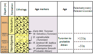
[Figure: Lithology and planktic datums in the Nandigama Formation in the Well Nandigama-A (after well completion report, ONGC, Raju, 2017)]
[Figure: A revised stratigraphy chart for the Jurassic and Cretaceous of the KG Basin showing lithological units, their age limits and paleoenvironmental setting (present study) in Raju et al., 2021, ONGC Bulletin, Special Issue, Vol. 56, No. 2]
Relationships and Distribution
Lower contact
It unconformably overlies the basement rock.
Upper contact
It is overlain unconformably by HG-HR unit. (Vanadurru Fm)
Regional extent
GeoJSON
Fossils
In Well VNS-A, the Nandigama Formation contains Characteristic planktic foraminifera, Hedbergella gorbachikae, H.planispira, Microhedbergella, G.cf. ferrolensis, Ticinella bejaouaensis. In Well Nandigama-A, Foraminiferal markers, Hedbergella planispira, Rotalipora brotzeni, Whiteinella baltica and Dicarinella canaliculata In Well Aibhimavaram-A, Foraminiferal markers include only agglutinated foraminifera (AF) in the lower part, and planktic markers include M.renzi and H.helvetica in the upper part.
Age
Depositional setting
Bathymetry varies from 50 m - deeper than 100 m.
[Figure: Revised age and paleoenvironments/paleobathymetry of formations of Jurassic-Cretaceous succession in KG Basin in Raju et al., 2021, ONGC Bulletin, Special Issue, Vol. 56, No. 2]
Additional Information
